
Dublin Bay Nautical Map, Antique Irish Nautical Chart, Dublin Bay coastal Chart, historic Irish sea chart.
Dublin Bay Nautical Map
€37.50
Description
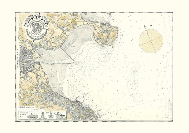
This is a Coastal Chart of Dublin Bay, Ireland about 1830. It shows the port with a very detailed city street plan as well as Dun Laoghaire, Dalkey and Howth with soundings and much of the hinterland with topography in the style of map making in the early 1800s.
I acquired a number of maps of this area and drew this map using pen and ink. Just to enhance it I used a light ochre/ yellow wash on the land.
It is A2 in size 594mm x 420mm on 280gsm paper. It is digitally printed from a high quality image capture.
It will be posted in a strong postal tube.
Materials
pen, ink, watercolor
Dimensions
Height: 420 Millimetres; Width: 594 Millimetres
FREE WORLDWIDE SHIPPING!
No quibble return policy. !!- if you’re not happy you may return the item for a full refund, please contact us within 14 days of receiving the map
Edel Scally –
Edel Scally 05 Sep, 2019
Purchased item: 5* Rating
Katie Camacho –
Katie Camacho 25 Jul, 2020
Purchased items: 5* Rating
These maps are beautiful! They are made out of high quality materials. They’re seriously even more gorgeous in person than they are in the photos. Delivery was quick and efficient and communicating with the seller was easy. Excellent experience
Matthew –
Matthew 11 Jun, 2020
Purchased items: 5* Rating
Absolutely gorgeous maps I’m using them in my study and they are perfect.
Matt –
Matt 15 May, 2020
Purchased items: 5* Rating
Brilliant item. High quality, beautifully made and great attention to detail. Dispatch was quick and communication was great. Highly recommended.
Deb –
Deb 21 Apr, 2020
Purchased items: 5* Rating
Love it! Can’t wait to get it framed and hung in our new wine country abode
Linda Londo –
Linda Londo 25 Mar, 2020
Purchased items: 5* Rating
Beautiful map Mark, it will be matted and framed and placed in my husband’s den. Such good work. Thank you.